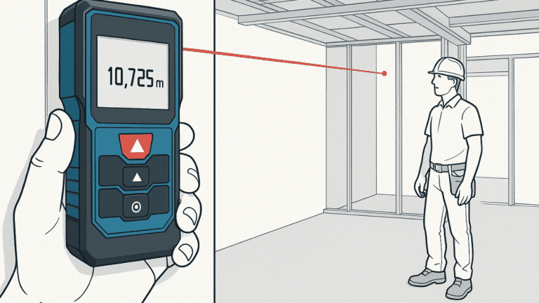
How does the altimeter work? This instrument measures altitude by detecting changes in air pressure. As you climb higher, atmospheric pressure decreases. The altimeter senses this pressure change and converts it into altitude measurement, displaying your current height above a reference point.
The altimeter is essential for aviation, aerospace technology, and altitude tracking. Understanding how a barometric altimeter works helps pilots, students, and enthusiasts grasp the fundamental principles of flight navigation and safety.
What Is an Altimeter?
An altimeter is an instrument that measures altitude. It tells you how high you are above a reference point, typically sea level or the ground below.
The term comes from Latin “altus” (height) and Greek “metron” (measure). Most altimeters work by measuring barometric pressure, making them pressure-based altimeter devices used in aircraft instruments worldwide.
Key points about altimeters:
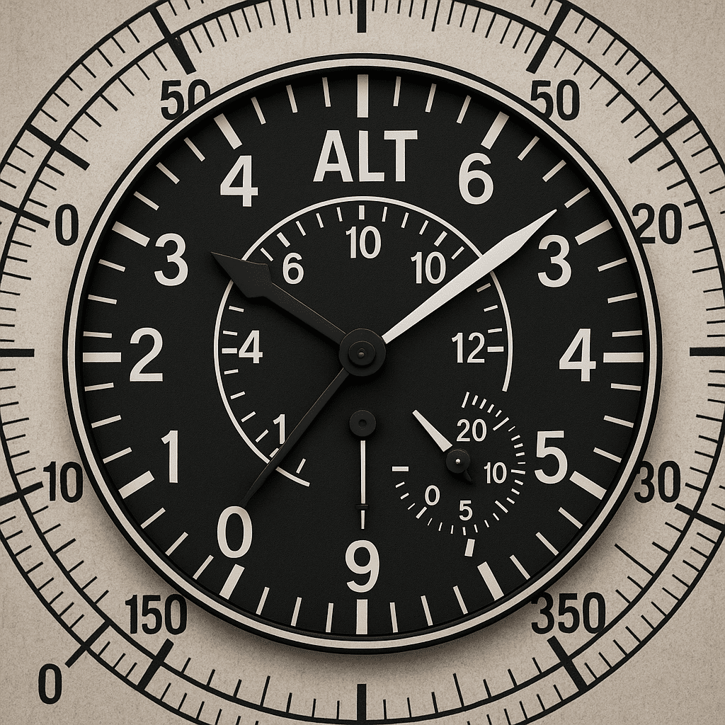
Standard aircraft altimeter showing three indicator hands for altitude measurement
The Science Of Air Pressure and Altitude
The principle behind how barometric altimeter works is based on atmospheric pressure. Air pressure decreases predictably as altitude increases.
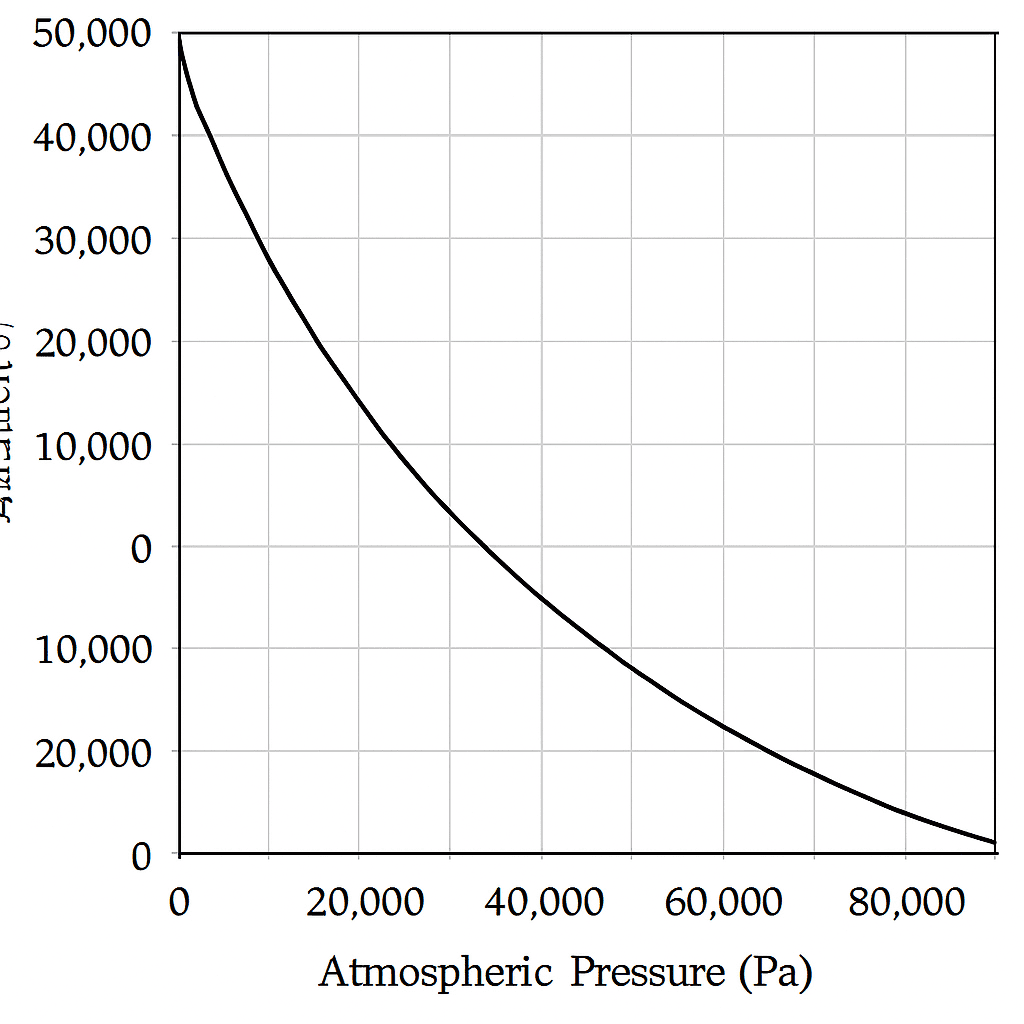
How atmospheric pressure decreases predictably with altitude according to ISA standards
Why Pressure Drops with Altitude
At sea level, the entire atmosphere above you creates pressure. As you climb, less air remains above you. With less air mass, atmospheric pressure decreases consistently.
Scientists developed the International Standard Atmosphere (ISA) model to predict this relationship. ISA provides a standard reference for aircraft performance and instrument calibration worldwide.
Standard Atmospheric Conditions Table
|
Altitude (ft) |
Pressure (inHg) |
Pressure (hPa) |
Temperature (°C) |
|---|---|---|---|
|
0 (Sea Level) |
29.92 |
1013.25 |
15 |
|
5,000 |
24.89 |
843 |
5 |
|
10,000 |
20.58 |
697 |
-5 |
|
18,000 |
16.88 |
572 |
-21 |
|
30,000 |
10.92 |
370 |
-45 |
Pressure Lapse Rate
Atmospheric pressure decreases approximately one inch of mercury per 1,000 feet of altitude. Alternatively, pressure drops about one hPa per 30 feet of altitude. This consistent relationship makes altitude measurement possible through pressure detection.
How Does an Altimeter Measure Altitude?
The altimeter working principle involves a sealed chamber that responds to atmospheric pressure changes. Understanding this mechanism explains how barometric altimeter works.
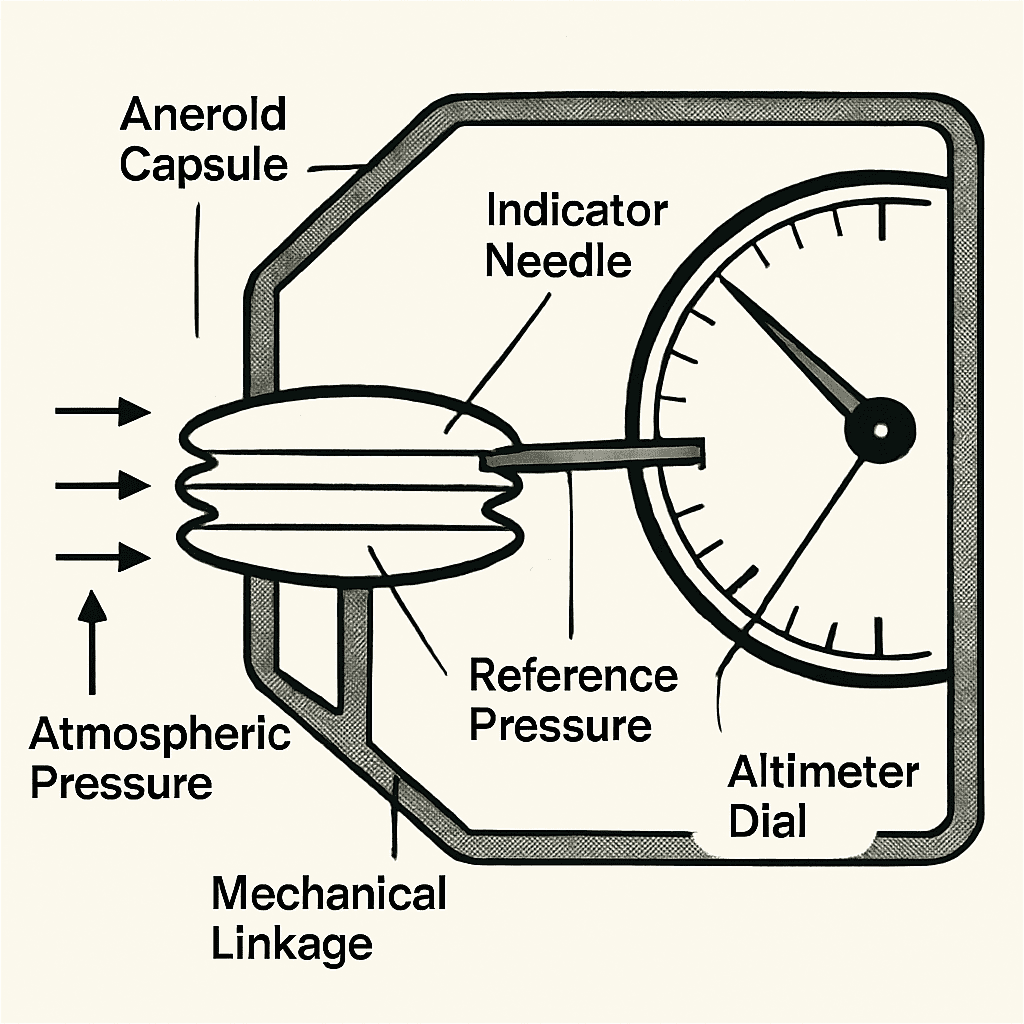
The Core Mechanism
Inside the altimeter is an aneroid capsule—a sealed metal bellows evacuated to approximately 29.92 inches of mercury (standard sea level pressure). This creates an internal reference pressure that never changes.
When you fly higher, atmospheric pressure outside decreases. The pressure difference increases between the high pressure inside the sealed capsule and the lower pressure surrounding it. This pressure difference causes the aneroid capsule to expand outward.
Connected to the capsule is a mechanical linkage system with gears. These gears amplify the small capsule movement (only millimeters) into large dial needle movement. The gears connect to indicator hands that show altitude on the dial face.
When you descend, the process reverses. External pressure increases, squeezing the capsule inward. The gears move in reverse, and indicator hands show decreased altitude.
The Three-Hand Display
The altimeter uses three rotating hands to display altitude:
Together, these hands show complete altitude. For example, triangle at 1, short hand at 5, long hand at 3 means 15,300 feet.
The Aneroid Capsule: How It Works
The aneroid capsule is the core component enabling how barometric altimeter works. This clever device converts atmospheric pressure into mechanical motion.
Construction
The capsule consists of thin corrugated metal (typically beryllium copper) formed into accordion-like bellows. Most altimeters use two or three capsules stacked together for increased sensitivity and accuracy.
Inside, the air has been pumped out almost completely, leaving a vacuum at 29.92 inches of mercury. This sealed internal pressure remains constant.
How It Operates
The evacuated interior provides a constant reference pressure. As external atmospheric pressure changes, the differential pressure between inside and outside moves the capsule.
When external pressure is high (low altitude), the pressure difference compresses the capsule inward. When external pressure is low (high altitude), the capsule expands outward from the greater internal pressure.
These small movements drive a mechanical linkage system that amplifies the motion through gears, ultimately rotating the altitude indicator hands on the dial face.
Temperature compensation using bi-metal strips ensures accuracy across temperature ranges, preventing errors from thermal expansion or contraction of components.
Types of Altimeters: How They Differ
Different altitude measurement applications require different altimeter types. The altimeter working principle varies by technology used.
Altimeter Types Comparison
|
Type |
How It Works |
Best For |
Accuracy |
Range |
|---|---|---|---|---|
|
Barometric |
Measures air pressure |
General aviation, commercial flight |
±50-100 ft |
Sea level to 50,000 ft |
|
Radio/Radar |
Radio waves to ground |
Landing, approach operations |
±2 ft |
0-2,500 ft above ground |
|
GPS |
Satellite triangulation |
Navigation, backup reference |
±100-400 ft |
Unlimited |
|
Laser |
Laser beam timing |
Surveys, drones, precision work |
±1 ft |
0-10,000 ft |
Which Type to Use
Barometric altimeters measure pressure altitude, crucial for ATC communication and standard flight levels. Radio altimeters provide absolute height above ground for landing operations. GPS altimeters complement barometric systems but shouldn’t replace them for primary altitude reference.
Modern aircraft combine multiple types. Barometric provides primary reference. Radio confirms ground distance during landing. GPS offers backup navigation data.
How to Read an Altimeter
The three-pointer display requires understanding each hand’s meaning and reading them systematically.
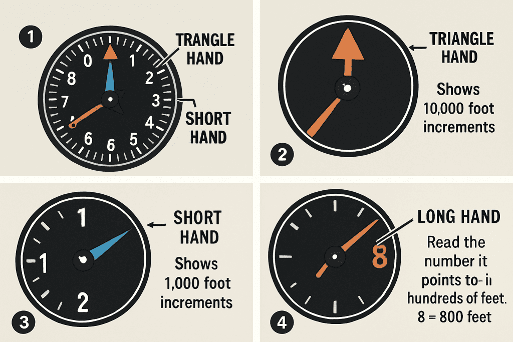
Step-by-step guide to reading the three hands: Triangle (10,000 ft), Short (1,000 ft), Long (100 ft)
Reading Steps
Step 1: Identify the Triangle Hand The small triangle pointer indicates 10,000-foot increments. Between 0-1 means 0-10,000 feet. Between 1-2 means 10,000-20,000 feet range.
Step 2: Read the Short Hand The thick short hand shows thousands of feet. Each number represents 1,000 feet.
Step 3: Read the Long Hand The thin long hand displays hundreds of feet.
Step 4: Combine the Values Add all three readings to get complete altitude.
Reading Examples
Triangle at 0, short hand at 2, long hand at 5 = 2,500 feet
Triangle at 0, short hand at 7, long hand at 3 = 7,300 feet
Triangle at 1, short hand at 5, long hand at 8 = 15,800 feet
Triangle at 2, short hand at 3, long hand at 0 = 23,000 feet
Triangle at 3, short hand at 0, long hand at 0 = 30,000 feet
The Kollsman Window
A small adjustable window displays the current pressure setting (like 29.92 or 1013). This critical adjustment ensures altitude accuracy. Pilots must update this setting as they fly into areas with different atmospheric pressures.
Altimeter Settings: QNH, QFE, and QNE
Air pressure varies with weather systems and location. Altimeters require adjustment to show accurate altitude.
Three Main Settings
QNH sets the altimeter to show height above sea level. This is the most common setting in the US below 18,000 feet. You get QNH from air traffic control or weather reports.
QFE sets the altimeter to show height above a specific airfield. When you set QFE on a runway, the altimeter reads zero feet. Some countries prefer this system, but the US rarely uses it.
QNE means setting your altimeter to standard pressure (29.92 inches or 1013.25 hPa). Above 18,000 feet, all aircraft use QNE to ensure consistent flight level separation.
Why Pressure Adjustment Matters
A 1-inch (0.34 hPa) pressure difference creates approximately 1,000 feet of altitude error. Failing to update the setting when pressure changes causes significant inaccuracy.
Old Pilot Saying: “High to Low, Look Out Below”
Flying from high pressure area to low pressure area without updating makes you lower than indicated. The same principle applies to temperature changes. Understanding this relationship prevents dangerous altitude errors.
Altimeter Errors: Common Sources
All altimeters have limitations. Understanding error sources is essential for safe altitude measurement.
Temperature Error
Altimeters assume standard temperature. But real temperature varies. Cold air is denser, causing pressure to decrease faster than standard. In cold weather, you’re actually lower than indicated.
For every 10°C below standard temperature, subtract approximately 4% of your indicated altitude. At 10,000 feet in very cold conditions (30°C below standard), you could be 1,200 feet lower than the altimeter shows.
In hot weather, the opposite occurs. Pressure decreases slower than standard, making you higher than indicated.
This error becomes dangerous near mountains or terrain in winter months.
Pressure Setting Error
If you don’t update your altimeter setting when pressure changes, you’ll have significant errors. A single inch difference in pressure setting creates about 1,000 feet of altitude error.
Always update your setting whenever you contact a new air traffic control frequency or every 100 nautical miles.
Static Port Blockage
Ice, insects, or debris can block the static port that feeds pressure to the altimeter. When this happens, your altimeter freezes at whatever altitude the blockage occurred.
You won’t see altitude changes during climb or descent. Most aircraft have an alternate static source valve that uses cabin pressure instead (though less accurate).
Position Error
Airflow around your aircraft’s static port varies with speed, altitude, and aircraft attitude. This creates small, predictable errors. Modern aircraft performance data accounts for these errors.
Instrument Error
Manufacturing tolerances create inherent accuracy limits. Good altimeters are accurate within 50 to 100 feet. This is why the FAA requires 24-month calibration testing for instrument flight operations.
Frequently Asked Questions
How accurate are barometric altimeters?
Standard aircraft altimeters are accurate within 50-100 feet under standard conditions with correct pressure setting. Accuracy degrades with temperature extremes, incorrect settings, or instrument wear.
Why does an altimeter need pressure adjustment?
Atmospheric pressure varies with weather systems and location. Without adjustment, an altimeter shows wrong altitude. Updating the setting with local pressure ensures accurate display.
What’s the difference between MSL and AGL?
Mean Sea Level (MSL) measures height above average ocean elevation. Above Ground Level (AGL) measures height above terrain directly below you. Pressure altimeters show MSL. Radio altimeters show AGL. Charts show elevations in MSL.
Can GPS altitude replace barometric altimeters?
No. GPS altitude is less accurate and uses a different reference. Air traffic control standards require pressure altitude. GPS serves as backup reference only.
What happens when a static port blocks?
The altimeter freezes at the current altitude and won’t show changes. Aircraft have alternate static sources using cabin pressure (less accurate). Prevention through preflight inspection is critical.
Why is temperature correction important?
Cold air is denser than standard, making you fly lower than indicated. Hot air is thinner, making you fly higher than indicated. This matters most near terrain or mountains.
Conclusion
The altimeter remains fundamental to how aircraft instruments work. Understanding how barometric altimeter works—measuring atmospheric pressure to determine altitude—is essential for aviation safety.
Key Principles
The altimeter working principle relies on atmospheric pressure decreasing predictably with altitude. An aneroid capsule responds to pressure differences, driving mechanical linkages that display altitude on indicator hands.
Proper pressure setting, understanding temperature effects, and regular calibration ensure reliable altitude measurement. Different altimeter types serve specific purposes: barometric for general flight, radio for landing, GPS for navigation backup, and laser for precision work.
Safety Critical
The pressure-based altitude measurement system has saved countless lives by providing pilots with accurate height information for safe navigation and terrain clearance. Understanding altimeter operation, limitations, and error sources remains critical for all aviation operations.
The fundamental how altimeter measures height through atmospheric pressure detection remains unchanged nearly a century after invention. This proven principle continues as the aviation industry standard for altitude measurement and air traffic control separation.


